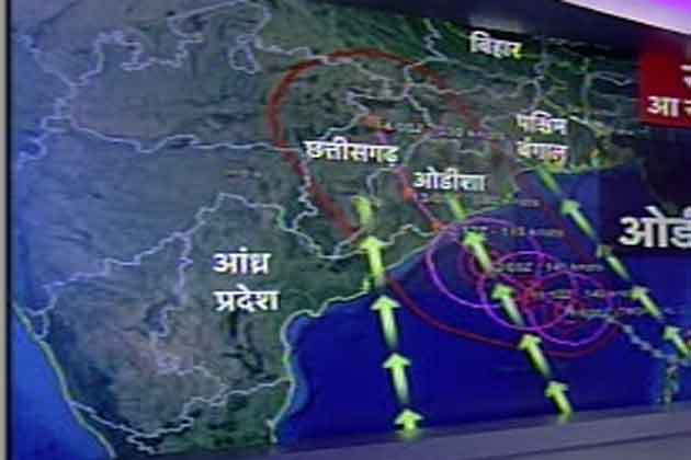
Warning for Odisha, Andhra Pradesh and West Bengal
পশ্চিম বঙ্গ সরকার এখনো পুজোর ছুটিতে,বাংলা উপকুলের মানুষকে বাঁচানোর তত্পরতা নেই মা মাটি মানুষ সরকারের
आंध्र प्रदेश, ओडिशा में आज शाम दस्तक देगा तूफान
Tropical Cyclone Phailin information
Cyclone Phailin: Naveen urges Antony to keep forces ready
Cyclone Phailin threatens 12 million, says disaster authority
পলাশ বিশ্বাস
Images for Cyclone Phailin
2 days ago
21 hours ago
1 day ago
1 day ago
TROPICAL CYCLONE PHAILIN Tracker | Cyclocane
TROPICAL CYCLONE PHAILIN Alternate Tracking Map. Alternate tracking maps are ...TROPICAL CYCLONE PHAILIN Watches and Warnings. Watches and ...
Cyclone Phailin LIVE: `Super storm` approaches at 220 kmph ...
zeenews.india.com/.../cyclone-phailin-live-odisha-fears-a-repeat...
14 hours ago - The Joint Typhoon Warning Center (JTWC), a Hawaii-based forecasting outpost of the US Navy has put the strength of Cyclone Phailin as that ...


Tropical Cyclone Phailin information
Resources and maps for those affected by Phailin Cyclone Phailin Phailin threatens 12 million, says NDMATwelve million people along India's eastern coast face mass disruption as a powerful cyclone bears down on the region in the next 24 hours, the head of the NDMA said on Friday. Full Article | Video: Phailin growing stronger नई दिल्ली। समुद्री तूफान पाइलीन की आहट से देश के चार राज्यों पर बड़ा खतरा मंडरा रहा है। ये चक्रवाती तूफान दो सौ किलोमीटर प्रति घंटे से ज्यादा की रफ्तार से बंगाल की खाड़ी से भारत की तरफ लगातार बढ़ रहा है। इसके शनिवार की शाम तक ओडिशा के तट से टकराने की आशंका है। इसका दायरा इतना बड़ा होगा कि ओडिशा और आंध्र प्रदेश के करीब 20 जिलों के अलावा बिहार और पश्चिम बंगाल के कुछ हिस्से भी इसकी चपेट में सकते हैं। करीब सवा करोड़ लोगों के तूफान से प्रभावित होने की आशंका है। महातूफान के आने की आहट है, जिसके खौफ में जी रहे हैं देश के दो राज्य, तटीय उड़ीसा और आंध्र प्रदेश। मौसम विभाग ने सावधान कर दिया है। पाइलीन को महातूफान इसलिए कहा जा रहा है क्योंकि ये तूफान 200 से लेकर 250 किलोमीटर की रफ्तार से तट से टकरा सकता है। जाहिर है जब हवा की रफ्तार करीब ढाई सौ किलोमीटर प्रति घंटे की हो तो जरा सोचिए क्या होगा कच्चे और कमजोर मकानों का। जाहिर है महातूफान की भयानक रफ्तार के आगे कच्चे और कमजोरर मकान उड़ जाएंगे। बिजली के तार और पोल भी तूफान में उड़ सकते हैं। मोबाइल टॉवर गिर सकते हैं या उन्हें नुकसान हो सकता है यानि बिजली हो, या फिर संचार नेटवर्क सब पर इसका बुरा असर पड़ सकता है। वो ठप हो सकते हैं। डीजी मेट लक्ष्मण सिंह राठौर ने बताया कि इससे काफी नुकसान होने की संभावना है। संचार के साधन और रास्ते टूट सकते हैं। घरों को नुकसान हो सकता है। सबसे ज्यादा नुकसान उड़ीसा और आंध्रप्रदेश में होगा। सैटेलाइट की तस्वीरों में बंगाल की खाड़ी के ऊपर दिख रहा चक्रवाती तूफान पाइलीन धीरे धीरे और तेज होता जा रहा है। गुरुवार को मौसम विभाग ने कहा था कि तूफान की रफ्तार 185 किलोमीटर तक होगी। लेकिन शुक्रवार को मौसम विभाग ने बताया कि पाइलीन तूफान शनिवार को 200 से लेकर 250 किलोमीटर की रफ्तार वाली हवाओं के साथ ओडिशा में गोपालपुर के पास तट से टकराएगा। लक्ष्मण सिंह राठौर का कहना है कि तूफान 175 प्रति घंटे की रफ्तार से कल तक चल रहा था लेकिन आज इसकी 200-220 प्रति घंटे की रफ्तार है और आगे संभावना है यही तीव्रता रहेगी। गोपालपुर के पास वो मेन लैंड को टच करेगी। महातूफान कितना बड़ा और ताकतवर हो सकता है इसका अंदाजा इस बात से लगता है कि फिलहाल बंगाल की खाड़ी में उसका आकार भारत के आकार का करीब आधा है। पाइलीन की वजह से ओडीशा और आंध्र के 23 जिलों पर संकट मंडरा रहा है। सबसे ज्यादा असर तटीय जिलों में होगा। जो जिले सबसे ज्यादा प्रभावित होंगे वो हैं ओडीशा के गंजाम, पुरी, केंद्रपाड़ा और जगतसिंहपुर। ओडीशा में करीब 1 करोड़ लोग तूफान से प्रभावित हो सकते हैं। आंध्र प्रदेश का श्रीकाकुलम भी खासा प्रभावित हो सकता है और आंध्र में करीब 25 लाख लोग प्रभावित हो सकते हैं। मौसम विभाग के मुताबिक तूफान पाइलीन के आने से समुद्र भी रौद्र रूप धारण कर सकता है। 4 से 6 मीटर तक उंची लहरें उठ सकती हैं। इस वजह से नदियों का पानी समुद्र में नहीं जा सकेगा बल्कि समुद्र का पानी ही नदियों में आ जाएगा। इससे नदियां उफन जाएंगी जिस वजह से निचले इलाकों में बाढ़ जैसे हालात बन जाएंगे। शुक्रवार सुबह से ही इन इलाकों में तेज बारिश और हवाएं शुरू हो गई हैं। तूफान और तेज बारिश की वजह से तटीय इलाकों में सड़कें भी कट सकती हैं जिससे यातायात ठप हो सकता है। तेज हवा के चलते हवाई यातायात पर भी असर पड़ सकता है। यही नहीं 150 से 250 मिलिमीटर तक भारी बारिश हो सकती है। महातूफान के मद्देनजर तूफान कंट्रोल रूम बनाया गया है। महातूफान के मद्देनजर ओडीशा और आंध्र की सरकारों ने तमाम अधिकारियों के साथ बैठक की है। हालात पर लगातार नजर रखी जा रही है। सेना और वायुसेना अलर्ट पर हैं। निचले इलाकों से लोगों को पूरी तरह से हटाने का मौसम विभाग ने सुझाव दिया है। तूफान की चपेट में आने वाले इलाकों में राहत कार्य चलाने के लिए हेलीकॉप्टर और भोजन के पैकेट तैयार रखे गए हैं। मछुआरों को समुद्र में जाने से मना कर दिया गया है। साथ ही रेल और सड़क परिवहन के संचालन में भी सावधानी बरतने का सुझाव दिया गया है। मौसम विभाग के मुताबिक तूफान के कारण शनिवार की सुबह से तटीय ओडीशा और आंध्र प्रदेश के साथ-साथ पश्चिम बंगाल में बेहद भारी बारिश होगी। इन राज्यों के आसपास के इलाकों में भी बारिश होगी। हालांकि मौसम विभाग के मुताबिक फिलहाल इसे सुपर साइक्लोन कहना सही नहीं होगा। लक्ष्मण सिंह राठौर के मुताबिक सुपर साइक्लोन कहना सही नहीं होगा जब तक कि 6.5 के लेवल को पार ना ले। कलिंगपट्टनम से पराद्वीप तक हमने अलर्ट जारी किया है। साइक्लोन के टकराने के बाद नुकसान कम इसके लिए हमने प्रबंध किया है। इस महातूफान का असर ओडीशा और आंध्र प्रदेश के अलावा बिहार, बंगाल और झारखंड पर भी पड़ सकता है। बिहार के कोसी, गया, नवादा और बिहार शरीफ पर तूफान का असर हो सकता है। तेज बारिश और हवाएं चल सकती हैं। इन राज्यों में भी अलर्ट जारी कर दिया गया है। आपदा प्रबंधन को किसी भी मुश्किल से निपटने के लिए तैयार रहने को कहा गया है। Cyclone Phailin: Naveen urges Antony to keep forces readyAs cyclone "Phailin" moved towards Odisha coast and lay centred about 850 km from Paradip, Chief Minister Naveen Patnaik on Thursday sought the help of defence forces to meet the impending situation. "Our past experience indicates that despite the state government's preparedness, impact of a very severe cyclonic storm requires support of the defence forces to mitigate the effects of extreme weather events," Patnaik said in a letter to Defence Minister AK Antony. Noting that on previous occasions in 2007, 2008 and 2011 defence forces had extended commendable cooperation to the state government in relief and rescue operations, Patnaik said this time also the cyclone is expected to leave an impact on life and property. "I would request you to kindly consider issuing standing instructions to the defence forces, specially the Air Force and the Navy, to remain in readiness to extend support to the state administration in relief and rescue operation as and when required," the Chief Minister said in the letter. Earlier, the state government had also informed the Union Ministry of Home Affairs to keep their choppers ready for relief and rescue work in the state. |

LIVE: Cyclone Phailin shows no signs of weakening as it heads for Gopalpur
Cyclone Phailin threatens 12 million, says disaster authority
People watch as waves from the Bay of Bengal approach the shore at Podampata village in Ganjam district, Odisha October 11, 2013.
Credit: Reuters/Stringer
By Nita Bhalla
Sat Oct 12, 2013 12:45am IST
NEW DELHI (Thomson Reuters Foundation) - Twelve million people along India's eastern coast face mass disruption as a powerful cyclone bears down on the region in the next 24 hours, the head of the National Disaster Management Authority (NMDA) said on Friday.
Meteorologists predict Phailin could be the most catastrophic storm to hit India in 14 years, when a super cyclone pounded Odisha, leaving 10,000 people dead.
Now in the Bay of Bengal, Cyclone Phailin is forecast to reach the coast of Andhra Pradesh and Odisha states on Saturday evening, bringing gale-force winds, lashing rains, storm surges and widespread flooding.
"The affected populations ... should be about 1.2 crores (12 million)," Shashidhar Reddy, the NMDA's vice-chairman told a news conference.
Mass evacuations are underway and around 300,000 people living in coastal villages have so far been moved to cyclone shelters and schools built on elevated areas, he said, adding that extensive damage to crops, property and roads was expected.
The Indian army, navy and air force are also on standby and 1,600 members of the National Disaster Response Force have been deployed for rescue and relief operations in districts such as Ganjan, Puri, Jagatsinghpur, Srikakulam and Vizianagaram, which lie directly in the path of storm.
India's disaster preparedness has improved dramatically in recent years, and aid workers praised precautions taken by authorities for Phailin such as early warning, pre-positioning of rations in shelters and orderly evacuations.
But they warn that preparations could be tested by Phailin's predicted wind speeds of more than 315 kph (196 mph) and wave surges that some forecasts say could reach 6 metres (20 feet).
Last Updated: Saturday, October 12, 2013, 09:15

Zee Media Bureau/Ajith Vijay Kumar
9.05 am: Cyclone Phailin shows no signs of weakening, now centred around 250 km from Gopalpur.
8.45 am: Odisha state control number: 0674-2534177. District control room numbers: Ganjam 06811-263978, Puri 06752-223237, Kendrapara 06727-232803, Jagatsinghpur 06724-220368, Balasore 06782-262674, Bhadrak 06784-251881, Mayurbhanj 06792-252759, Jajpur 06728-222648, Gajapati 06815-222943, Dhenkanal 06762-221376, Khurda 06755-220002, Keonjhar 06766-255437 and Cuttak 0671-2507842.
Also Read: Cyclone Phailin: All that you need to know
8.35 am: Latest: Cyclone Phailin just 260 km away from Gopalpur.
8.33 am: East Coast Railway Helpline number: Vizag-0891-2505793,08935-249672, Vizianagaram-08922-225510, Srikakulam-08942- 287222
8.30 am Ganjam district of Odisha braces for Cyclone Phailin. Rangeilunda, Chikiti Chatrapur, and Ganjam blocks of the district are on the path of the super storm.
Also Read: Naveen appeals to people not to panic over cyclone
8.15 am: Over three lakh people moved to safer locations in Odisha and Andhra Pradesh. Special medical teams have been deployed across coastal Odisha, Andhra Pradesh.
8.05 am: Warning Signal No 10 (great danger) raised at Gopalpur and Puri ports. Warning Signal No 9 at Paradeep and Chandabali.
7.47 am: Phailin approaching fast. Heavy rains and strong winds batter coastal Odisha and north Andhra Pradesh. Frequent power cuts add to people's woes in Bhubaneswar and other cities.
7.35 am: Phailin is holding strong as it heads to the Odisha-Andhra coast at over 200 kmph. Landfall will occur between 5.30 pm-6.30 pm near Gopalpur and Brahmapur in Ganjam district. Experts predict that it may turn out to be the strongest ever cyclone to hit the Indian coast, breaking the record held by the 1999 monster that devastated Odisha.
7.20 am Helpline number: Odisha Central Control Room 0674-2534177
7.00 am: US Navy's Joint Typhoon Warning Centre and London-based Tropical Storm say that Cyclone Phailin will come with winds reaching 315 kmph on landfall, classifying Phailin as a Category 5 storm - the most powerful. As per the IMD, Phailin winds would reach only 220 kmph.
Also Read: Cyclone Phailin 'may be worse than Katrina'
6.50 am: 1,600 National Disaster Response Force personnel have taken up positions in Ganjam, Brahmapur, Puri, Jagatsinghpur and Srikakulam to assist in rescue and relief operations. The Indian Army, Navy and Air Force are also on standby.
Also Read: OPCC opens control room
6.45 am: Scouting winds have picked up speed in Gopalpur, the city closest to the area where Cyclone Phailin will make landfall.
Besides Gopalpur, the other towns which would face the brunt of the incoming super storm are Baruva, Ganjam, Satpada, Puri and Srikakulam.
6.35 am: Rains have begun in the danger zone areas and in state capital Bhubaneswar. Electricity supply was disrupted last night in some parts of the state, reports said.
6.30 am: Latest update from IMD - The very severe cyclonic storm Phailin over westcentral and adjoining eastcentral Bay of Bengal moved northwestwards during past six hours and lay centred at 02.30 am over westcentral and adjoining eastcentral Bay of Bengal at about 355 km south-southeast of Paradip, 320 km southeast of Gopalpur, and 315 km east-southeast of Kalingapatnam.
At landfall, Phailin will have a sustained wind speed of 210-220 kmph.
As per the IMD, heavy to very heavy rain falls would occur over coastal Odisha during next 48 hours and over interior Odisha from Saturday afternoon for subsequent 48 hours. Rainfall at most places with isolated heavy to very heavy falls would also occur over north coastal Andhra Pradesh.
Phailin will cause storm surge with height of 3.0 to 3.5 meteres at landfall.
The super storm will lead to large scale disruption of power and communication lines and also disrupt rail and road traffic, the update said.
6. 25 am: Phailin to come ashore late afternoon or early evening. As per the IMD it will make landfall around 5.30-6 pm this evening.
6.15 am: US National Hurricane Center says Phailin's strength is equivalent of a Category 5 hurricane and may cause extensive damage.
6.12 am: National Disaster Management Authority says 12 million people could be affected by Cyclone Phailin.
Also Read: NDRF teams deputed in Odisha, Andhra Pradesh
6.10 am: Close to two lakh people have been evacuated in Odisha; in Andhra Pradesh over 60,000 have been moved to shelters so far.
6.00 am: The Odisha government has approached the RBI to facilitate government payments towards relief expenditure.
Also Read: Anemometer failed to read wind speed of super cyclone in 1999
5.45 am: Residents in the danger zone had a harrowing time on Friday as there has been a steep increase in vegetable prices and candles.
5.40 am: The IMD predicts a storm surge with height of 3.0 to 3.5 meters which will inundate low lying areas of Ganjam, Khurda, Puri and Jagatsinghpur districts of Odisha and Srikakulam district of Andhra Pradesh during landfall.
5.30 am: Latest IMD update - Cyclone Phailin over westcentral and adjoining eastcentral Bay of Bengal has moved west-northwestwards during past 6 hours and lay centred at 11.30 pm (Friday) at about 375 km south-southeast of Paradip, 345 km southeast of Gopalpur, and 340 km east-southeast of Kalingapatnam.
It would move northwestwards and cross north Andhra Pradesh and Odisha coasts between Kalingapatnam and Paradip, close to Gopalpur by this evening.
At landfall, Cyclone Phailin will have a maximum sustained wind speed of 210-220 kmph.
পশ্চিম বঙ্গ সরকার এখনো পুজোর ছুটিতে,বাংলা উপকুলের মানুষকে বাঁচানোর তত্পরতা নেই মা মাটি মানুষ সরকারের
উত্তরাখন্ড সরকার কেদারনাথের পর্যটকদের উদ্ধার করেই যেমন খালাস,স্থানীয় হাজারো হাজারো হিমালয়ের মানুষদের,শত শত নিশ্চহ্ন উপত্যকা গ্রামের দিকে ফিরেও তাকায়নি, পর্য়টন বাঁচাতে
উদ্ধার কাজ শেষ না করেই কেদারনাথে শুরু হল পুজো,তেমনিই পশ্চিমবঙ্গ সরকার ও পশ্টিমবঙ্গীয় মিডিয়ার একমাত্র চিন্তা কলকাতার করপোরেট পুজো
গ্রাম বাংলার ঝেড়ে সমর্থনে বিপুল পরিবর্তনে ক্ষমতায় আসা সরকারের বাদা অন্চল ও উপকুলবর্তী মানুষের জীবন মরণে কিছুই আসে যায় না
উড়ীষ্যার প্রতিটি জেলায় উদ্বাস্তু বাঙালি,সাইক্লোন জোনের সর্বত্র সারা দন্ডকারণ্য ও আন্দামানের উদ্বাস্তুদের নিয়ে বাংলার মাথাব্যতা নেই
নেই বাংলাদেশ বা সুন্দরবন নিয়ে ভাবনা চিন্তা
বেজন্মা দেবতারা মানুষের কথা বললেই খেউড়ের ঝড় তুলছে
আমাদের আর্তনাদের জবাবে শুরু হয়ে যায় ছুঁচোর কীর্তণ
বাংলা এখন সংহারকদের কবলে
বাংলা বাঁচাও
বাঙালি বাঁচাও
आंध्र प्रदेश, ओडिशा में आज शाम दस्तक देगा तूफान
नवभारत टाइम्स | Oct 12, 2013, 08.56AM IST


साइक्लोन के इलर्ट के बाद सभी तटीय इलाकों को खाली कराया जा रहा है।
नई दिल्ली।। आंध्र प्रदेश, ओडिशा और पश्चिम बंगाल में शनिवार शाम तक पेलिन तूफान से तेज बारिश, आंधी और बवंडर की आशंका है। कहा जा रहा है कि पेलिन अमेरिका में 2005 में आए तूफान कटरीना से भी ज्यादा तबाही मचा सकता है, जिसने 1,800 लोगों की जान ली थी। लोगों में इस तूफान को लेकर दहशत फैल गई है। पेलिन के प्रकोप से बचने के लिए हजारों लोग तटीय शहर पारादीप को छोड़ कर जा रहे हैं। करीब 30 हजार से ज्यादा लोग अब तक जा चुके हैं।
भारतीय मौसम विभाग के मुताबिक, इसकी गति 210 से 220 किलोमीटर प्रति घंटा हो सकती है। वैसे मीडिया रिपोर्ट्स के मुताबिक, यूएस नेवी के जॉइंट टाइफून वॉर्निंग सेंटर और लंदन के ट्रॉपिकल स्टॉर्म का अनुमान है कि रफ्तार 315 किलोमीटर प्रति घंटा होगी। यह कैटिगरी-5 यानी सबसे ताकतवर तूफानों में एक होगा।
मौसम विभाग ने पेलिन के मद्देनजर पश्चिम बंगाल, आंध्र प्रदेश और ओडिशा के तटीय इलाकों में अलर्ट जारी कर दिया है। उसका मानना है कि शनिवार की शाम के बाद तूफान की रफ्तार थमने लगेगी। इस बीच लाखों लोगों को सुरक्षित ठिकानों पर पहुंचाया गया और आर्मी को अलर्ट कर दिया गया। उड़ीसा के राहत कमिश्नर ने कहा है कि हम इसे सुपर साइक्लोन से कम नहीं मान रहे हैं। उड़ीसा में 1999 में आए सुपर साइक्लोन से 10 हजार लोग मारे गए थे।
क्या है पेलिन
पेलिन का मतलब सफायर (नीलम) होता है। पेलिन थाइलैंड का शब्द है। बीते 4 अक्टूबर को जापान के मौसम विज्ञान विभाग ने इसे थाइलैंड की खाड़ी में मॉनिटर करना शुरू किया। इसके बाद वेस्टर्न पैसिफिक बेसिन होता हुआ अंडमान सागर पहुंचा। फिर अंडमान द्वीप के मायाबंदर होते हुए पेलिन बंगाल की खाड़ी की ओर बढ़ गया। यहां इसे मॉनिटर करने के बाद भारतीय मौसम विज्ञान विभाग ने इसे पेलिन नाम दिया।
राजधानी तक असर
दिल्ली-एनसीआर के मौसम में अचानक आई तब्दीली की वजह बंगाल की खाड़ी से उठा तूफान पेलिन ही है। बंगाल की खाड़ी से तेज रफ्तार में चल रही हवा नमी भी साथ ला रही है। शुक्रवार की सुबह दिल्ली समेत उत्तर भारत के कई हिस्सों में बारिश इसी नमी के कारण हुई है। अनुमान है कि अगले 15 दिनों तक दिल्ली-एनसीआर में हल्की-फुल्की बारिश होती रहेगी। मॉनसून का सीजन खत्म होने की तारीख 21 सितंबर थी, लेकिन अब 15 अक्टूबर के बाद ही यह तय हो पाएगा कि यह सीजन कब तक चलेगा।
64 हजार लोगों को महफूज ठिकाना
पेलिन के शनिवार शाम तक ओडिशा में गोपालपुर और आंध्रप्रदेश के श्रीकाकुलम के बीच बंगाल की खाड़ी के तट तक पहुंचने की आशंका है। एहतियात के तौर पर आंध्र प्रदेश में श्रीकाकुलम, विजयनगरम, विशाखापत्तनम जिलों में करीब 64 हजार लोगों को सुरक्षित जगहों पर पहुंचाया जा रहा है।
रफ्तार 215 किमी/घंटा
आंध्र प्रदेश के राजस्व मंत्री एन रघुवीर रेड्डी ने कहा कि तूफान के तट पर पहुंचने पर 205 से 215 किमी प्रति घंटे की रफ्तार से हवा चल सकती है। कई बार हवाओं की स्पीड 235 किमी प्रति घंटे तक भी पहुंच सकती है और 25 सेमी तक जबर्दस्त बारिश होने की आशंका है।
पैसेंजर ट्रेनों पर असर
ईस्ट कोस्ट रेलवे ने चक्रवाती तूफान के मद्देनजर 24 पैसेंजर ट्रेन का टाइम बदलने या कैंसल करने का प्लान बनाया है। ये ट्रेनें विशाखापट्टनम और भदरक तथा हावड़ा-चेन्नै मेन लाइन रूट की हैं। इनमें पुरी-कटक-पुरी पैसेंजर, पारादीप कटक पैसेंजर, कटक-पारादीप पैसेंजर, पुरी-गुनूपुर-पुरी पैसेंजर, पुरी-राउरकेला पैसेंजर-पुरी कटक पैसेंजर, भदरक-कटक-भदरक पैसेंजर और कटक-पलासा-कटक पैसेंजर शामिल हैं।
तैयार रहें आर्म्ड फोर्सेज : एंटनी
रक्षामंत्री एके एंटनी ने आर्म्ड फोर्सेज से ओडिशा और आंध्र प्रदेश में मदद करने के लिए तैयार रहने को कहा। भारतीय वायु सेना के आईएल-76 विमान पहले ही नैशनल डिजास्टर रिलीफ फोर्स (एनडीआरएफ) की टीमों और उपकरणों को भुवनेश्वर ले जा चुके हैं। इंडियन एयरफोर्स को रायपुर, नागपुर, जगदलपुर, बैरकपुर, रांची और ग्वालियर सहित कई जगहों पर तैयार रखा गया है। ईस्टर्न एयर कमांड को बैरकपुर में मौजूद टास्क फोर्स के साथ रेस्क्यू ऑपरेशन में कोऑर्डिनेट करने के साथ काम करने के लिए कहे जाने के अलावा दो सी130जे विमानों, 18 हेलिकॉप्टरों, दो एएन-32 विमानों को तुरंत सूचना मिलने की स्थिति में तैयार रखा गया है।
सीएम ने लिया तैयारियों का जायजा
आंध्र के मुख्यमंत्री एन किरण कुमार रेड्डी ने चक्रवाती तूफान का सामना करने के लिए सरकार की तैयारियों की समीक्षा की और अधिकारियों को ऐहतियाती कदम उठाने को कहा। सचिवालय में 24 घंटे काम करने वाला कंट्रोल रूम खोला गया है। जिला कलेक्टरों को कहा गया है कि वे हालात से निपटने के लिए सभी जरूरी इंतजाम करें।
बिजली हड़ताल वापस
तटवर्ती आंध्र और रायलसीमा में राज्य बंटवारे के खिलाफ हड़ताल कर रहे बिजली कर्मचारियों ने मुख्यमंत्री के साथ बातचीत के बाद तटवर्ती आंध्र प्रदेश में तूफान के खतरे के मद्देनजर अपनी हड़ताल अस्थायी तौर पर वापस ले ली है। टीचर्स ने भी मुख्यमंत्री के साथ अपनी बातचीत के बाद अपनी हड़ताल वापस ले ली। अन्य सरकारी कर्मचारियों ने भी घोषणा की है कि वे चक्रवाती तूफान के मद्देनजर राहत और बचाव काम में शामिल होंगे।
वेस्ट बंगाल ने भी उठाया कदम
चक्रवात पेलिन के प्रभावों से निपटने के लिए पश्चिम बंगाल सरकार ने राज्य के तटीय इलाकों में डिजास्टर मैनेजमेंट टीम भेजी है। राज्य के आपदा प्रबंधन मंत्री जावेद खान ने बताया कि हमने डायमंड हार्बर और दीघा समेत पश्चिम बंगाल के तटीय इलाकों में कई डिजास्टर मैनेजमेंट टीमें भेजी है। राज्य सचिवालय में एक हेल्पलाइन शुरू की गई है। उन्होंने कहा कि हमने नागरिक रक्षा टीम से भी कहा है कि वे तटीय इलाकों तक पहुंचे ताकि किसी भी हालात से निपटा जा सके।
(Reuters) - Tens of thousands fled their homes in coastal areas of eastern India and moved to shelters on Friday, bracing for the fiercest cyclone to threaten the country since a devastating storm killed 10,000 people 14 years ago.
Large waves were already pounding beaches in Andhra Pradesh over a day before Cyclone Phailin was due to hit. Villagers were evacuated to schools in the north of the state and in neighbouring Odisha, while panic buying drove up food prices.
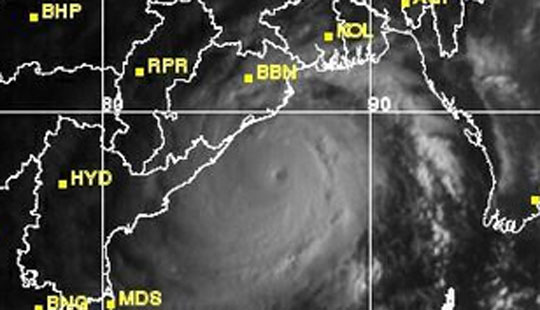
Satellite images showed Phailin some 500 km (310 miles) off the coast in the Bay of Bengal and likely to make landfall on Saturday evening, with widespread flooding expected from surges.
The images showed the storm covering an area roughly half the size of India. Some forecasters likened its size and intensity to that of hurricane Katrina, which devastated the U.S. Gulf coast and New Orleans in 2005.
Some 260,000 people were moved to safer ground and more were expected to be evacuated by the end of the day, authorities in the two states said. Not everybody was willing to leave their homes and belongings, and some villagers on the palm-fringed Andhra Pradesh coast said they had not been told to evacuate.
"Of course I'm scared, but where will I move with my family?" asked Kuramayya, 38, a fisherman from the village of Bandharuvanipeta, close to where the hurricane is expected to make to landfall, while 3.5-metre (12-foot waves) crashed behind him. "We can't leave our boats behind."
The Indian Meteorological Department said Phailin would hit between Kalingapatnam in Andhra Pradesh and the major port of Paradip in Odisha and predicted flooding from expected storm surges of about three metres (10 feet) above normal tides.
SUPER CYCLONE?
There was disagreement about the power packed by Phailin although most forecasters expected it to weaken upon reaching the coast. The Indian Meteorological Department described it as a "very severe cyclonic storm" with wind speeds of 210-220 km per hour (130-135 mph) and resisted upgrading it to a stronger "super cyclone."
But the U.S. Navy's Joint Typhoon Warning Centre predicted gusts of up to 315 kph.
London-based storm tracking service Tropical Storm Risk said Phailin was a super cyclone and placed it in the most intense Category 5 of powerful storms, evoking memories of the devastating 1999 storm when wind reaching speeds of 300 kph winds battered Odisha for 30 hours. Odisha officials agreed.
"Phailin will be no less than the 1999 super cyclone," Odisha state's Special Relief Commissioner, Pradeep Kumar Mohapatra, told Reuters. He said half a million people were expected to move to shelters in the state.
This time, however, the state government said it was better prepared. It broadcast cyclone warnings through loudspeakers and on radio and television as the first winds were felt on the coast and in the state capital, Bhubaneswar.
The authorities warned of extensive damage to crops, village dwellings and old buildings, as well as disruption of power, water and rail services. Shelters were being stocked with rations, and leave for government employees was cancelled.
"Within 12 hours of the cyclone strike, we will try to clear all the roads. Within 24 hours we will try to restore water supply and electricity," Mohapatra said.
Paradip stopped cargo operations on Friday, port chairman Sudhanshu Shekhara Mishra told Reuters. He said all vessels were ordered to leave the port, which handles coal, crude oil and iron ore. An oil tanker holding about 2 million barrels of oil, worth some $220 million, was among those moved, an oil company source said.
India's largest gas field - the Reliance Industries (RELI.NS)-operated D6 natural gas block - lies in the Cauvery Basin further down the east coast. The company said it was not expecting to be hit.
Katrina hit the U.S. Gulf coast on August 29, killing about 1,800 people, including many in New Orleans where levees failed to hold back storm surges.
It was one on the six biggest hurricanes - also known as cyclones and typhoons - ever recorded and caused $75 billion worth of damage.
(Additional reporting by Nita Bhalla, Nidhi Verma and Ratnajyoti Dutta; Writing by Frank Jack Daniel; Editing by Nick Macfie)
As Cyclone Phailin approaches Odisha, Defence Minister AK Antony has asked the armed forces to be prepared.
Two IL-76 aircraft have airlifted National Disaster Response Force teams and equipment to Bhubneshwar, official sources said.
Air Force assets have been kept on standby at various bases, including Raipur, Nagpur, Jagdalpur, Barrackpore, Ranchi and Gwalior.
The aircraft kept on standby include two C130Js, 18 helicopters, and two AN-32 aircraft, which can move at short notice.
Eastern Air Command has been asked to coordinate relief operations with the task force positioned at Barrackpore.
Odisha Chief Minister Naveen Patnaik on Thursday sought the help of the defence forces to meet the impending situation.
The severe cyclonic storm Phailin over the Bay of Bengal gained strength, and intensified further as it moved towards Odisha and Andhra Pradesh coast, officials of the India Meteorological Department said on Friday.
It would move northwestwards and cross north Andhra Pradesh and Odisha coast between Kalingapatnam and Paradip, close to Gopalpur (Odisha) by Saturday evening.
A very severe cyclonic storm with a maximum sustained wind speed of 205-215 kmph is expected.
Bhubaneswar: With the very severe cyclonic storm heading towards Odisha coast, the Congress today constituted a three-tier disaster management committee and opened a control room to undertake relief, rescue and rehabilitation activities.
"The OPCC has constituted a committee in state level, district level and block level to help the people likely to be affected by the impending cyclone," OPCC president Jaydev Jena said.
Besides taking members from youth, women and student wings, the OPCC asked its people to keep in touch with district collectors, tehsildars, block development officers and others associated with the relief and rescue operation during the calamity.
OPCC vice-president Samir Routray has been assigned the responsibility of the state level control room while senior leader Sk Matklub Ali will be incharge of Cuttack district. Other leaders who have been put in charge of different districts are: Prasad Harichandan (Puri), Chiranjib Biswal (Jagatsinghpur), Gurupada Nanda (Kendrapara), Kishore Panda (Nayagarh), Shivananda Ray (Balasore), Pradeep Majhi (Bhadrak), Kailash Acharya (Mayurbhanj), Kishore Patel (Keonjhatr), Kumudini Patnaik (Ganjam), Alekh Choudhury (Gajapati) and Amarnath Pradhan (Dhenkanal).
These leaders could be directly contacted over phone for any matter relating to cyclone disaster, Jena said.
Anemometer failed to read wind speed of super cyclone in 1999
Bhubaneswar: With another very severe cyclonic storm looming over the state, it was recalled that so high was the wind speed of the super cyclone that ravaged Odisha in 1999 that the anemometers at the IMD office and at Paradip had failed to record it.
"The speed of the wind was so high that the anemometer installed at Bhubaneswar and Paradip could not record it," a report prepared by United Nations Development Programme, Odisha Disaster Management Authority and Utkal University said.
On October 29, 1999, the super cyclone with a wind speed of 300 mph had struck the state making it probably the greatest cyclonic disaster ever recorded in the last century, the report said.
The cyclone heading toward Gopalpur in Odisha's Ganjam district beside Andhra Pradesh now has a relatively lesser wind speed of 175 to 185 kmph.
The 1999 super cyclone centred over coastal areas of the state for three days was accompanied by torrential rain as a tidal surge of about 7 to 10 meter swept 40 to 50 km inland, it said.
The magnitude of the devastation was such that it came to be known as a 'super cyclone'.
While the cyclonic storm heading for Odisha now originated from near the Andaman Islands in the sea, the 1999 super cyclone had also originated from about 550 km east of the same area as a depression.
The 1999 storm with a diameter of 200 km and its eye at Paradip had made landfall near Ersama in Jagatsinghpur district at 10.30 am, it said.
Local IMD director Sarat Sahu today said the impending storm would cause a storm surge of about 1.5 metre to 2 metre this time, while in 1999 the state witnessed it at 7 meter to 10 metre.
The storm in 1999 led to 45 cm to 95 cm of rainfall affecting 14 coastal districts, 28 coastal towns and two major cities of Bhubaneswar and Cuttack.
While the official death toll then was 9,885 people, an estimated 1,500 children were orphaned, the report said. Of the total casualty, Jagatsinghpur district alone had accounted for 8,119 people.
At least 13 million people, including 3.3 million children, 5 million women and nearly 3.5 million aged people were affected in 1999.
Unofficial sources, however, estimated the toll to be above 50,000. The storm had left 7,505 injured, a loss of 3,15,886 head of cattle, 16,50,086 houses damaged, 23,129 houses washed away, 7,46,337 houses fully destroyed and 8,80,620 houses partially damaged.
ভয়াবহ পাইলিনের ভ্রূকুটি, সতর্ক ওড়িশাকে, ভারী বৃষ্টির সম্ভাবনা রাজ্যে
Tag: Cyclone Phailin, Odisha, Andhra Pradesh
Last Updated: October 11, 2013 13:46
গঞ্জাম, পুরী, জগতসিংপুর এবং খুরদায় পাইলিনের প্রভাবে সবচেয়ে বেশি ক্ষয়ক্ষতি হওয়ার আশঙ্কা। সতর্কতা হিসেবে এখনই ওড়িশা উপকূল খালি করার নির্দেশ দিয়েছে নবীন পট্টনায়েক সরকার। ওড়িশা প্রশাসন সূত্রে খবর, এখনই একশো কিলোমিটার বেগে ঝড় শুরু হয়েছে উপকূলবর্তী জেলাগুলিতে। আগামিকাল তা আরও শক্তি বাড়িয়ে আছড়ে পড়ার আশঙ্কা। পরিস্থিতি মোকাবিলায় তৈরি রাখা হয়েছে বিপর্যয় মোকাবিলা বাহিনীকে। পুজোয় পুরী যাওয়া রাজ্যের অধিকাংশ পর্যটকই আজ ধৌলি ও দুরন্ত এক্সপ্রেসে ফিরে এসেছেন।
পাইলিনের প্রভাব পড়তে পারে এ রাজ্যেও। সাইক্লোন জেরে ভারী বৃষ্টির সম্ভাবনা রাজ্যের উপকূলবর্তী এলাকায়। ওড়িশা উপকূলে আছড়ে পড়তে চলেছে ঘূর্ণিঝড়। ওড়িশার অত্যন্ত কাছে বলে দিঘাতে সতর্কতা জারি করা হয়েছে। সতর্কতা জারি করা হয়েছে উদয়পুর, শঙ্করপুর, তাজপুর ও মন্দারমণিতে। প্রশাসনের তরফ থেকে মাইকিং শুরু হয়েছে। পর্যটকদের দিঘা, মন্দারমণি, শঙ্করপুর ও তাজপুর ছেড়ে যেতে বলা হয়েছে। দিঘায় না আসতে অনুরোধ করা হয়েছে পর্যটকদের। তৈরি রয়েছে বিপর্যয় মোকাবিলা দল। মত্স্যজীবীদের সমুদ্রে মাছ ধরতে যেতে নিষেধ করা হয়েছে। সমস্ত ধরনের সতর্কতা জারি করা হয়েছে। পরিস্থিতি মোকাবিলায় দিঘাতেই দফায় দফায় বৈঠক করেছেন প্রশাসনিক কর্তারা।
Like This Page · October 10
Untitled Album (37 photos)
মা আসছেন মাটিতে।
মানুষের পাশে, সবার সাথে।
আজ মহাষষ্ঠী।
সকলকে জানাই অনেক অনেক শারদ শুভেচ্ছা।
I am uploading few photographs of Puja I have received, for all of you to see.


You and 13,576 others like this.
Mamata Banerjee
Today is Maha Chaturthi. Only two days are left for Durga Puja. We all are now in great Puja mood.
These days, I am visiting a number of Puja mandaps for inauguration.
Creativity is the hallmark of Bengal. This is clearly evident from the fascinating structures and décor of various Puja mandaps. We can call it Biswa Bangla Brand.
Lots of foreign tourists and visitors from other states are coming to Kolkata to enjoy Durga Puja festival.
They are here in Bengal to be inspired by this creativity.
I wish all of you and the visitors in Bengal a very happy Durga Puja.
Bulletin No.: BOB 04/2013/28
Sub: Very Severe Cyclonic Storm 'PHAILIN' over westcentral and adjoining eastcentral Bay
of Bengal: Cyclone Warning for North Andhra Pradesh and Odisha Coast.
The very severe cyclonic storm, PHAILIN over westcentral and adjoining eastcentral Bay of
Bengal moved northwestwards during past 6 hours and lay centred at 0230 hrs IST of today, the 12 th
October 2013 over westcentral and adjoining eastcentral Bay of Bengal near latitude 17.1 0 N and
longitude 86.8 0 E, about 355 km south-southeast of Paradip, 320 km southeast of Gopalpur, and 315
km east-southeast of Kalingapatnam. It would move northwestwards and cross north Andhra
Pradesh and Odisha coasts between Kalingapatnam and Paradip, close to Gopalpur (Odisha) by
evening of today i.e. the 12 th October, 2013 as a very severe cyclonic storm with a maximum
sustained wind speed of 210-220 kmph.
Estimated track and intensity of the system are given in the Table below:
Date/Time(IST)
Position
(Lat. 0 N/ Long. 0 E)
Sustained maximum surface
wind speed (kmph)
Category
12-10-2013/0230 17.1/86.8 210-220 gusting to 235 Very Severe Cyclonic Storm
12-10-2013/0530 17.4/86.4 210-220 gusting to 235 Very Severe Cyclonic Storm
12-10-2013/1130 18.3/85.5 210-220 gusting to 235 Very Severe Cyclonic Storm
12-10-2013/1730 19.1/84.9 210-220 gusting to 235 Very Severe Cyclonic Storm
12-10-2013/2330 19.8/84.5 100-110 gusting to 120 Severe Cyclonic Storm
13-10-2013/1130 20.5/84.1 50-60 gusting to 70 Deep Depression
13.10.2013/2330 21.5/83.7 40-50 gusting to 60 Depression
Warning for Odisha, Andhra Pradesh and West Bengal
(i) Rainfall at most places with heavy to very heavy falls at a few places and isolated extremely
heavy falls (≥ 25 cm) would occur over coastal Odisha during next 48 hrs and over interior
Odisha from today afternoon for subsequent 48 hrs. Rainfall at most places with isolated
heavy to very heavy falls would also occur over north coastal Andhra Pradesh during next 48
hrs. Isolated heavy to very heavy rainfall would occur over coastal areas of West Bengal
commencing from afternoon of today i.e. the 12 th October.
(ii)
Gale wind: Squally winds speed reaching 55-65 kmph gusting to 75 kmph would continue along and
off Odisha and north Andhra Pradesh coasts during next 6 hours. It would increase in intensity
thereafter with gale wind speed reaching 100-150 kmph from forenoon and 210-220 kmph along and
off coastal districts of north coastal Andhra Pradesh and south Odisha at the time of landfall. State
of Sea along and off Odisha and north Andhra Pradesh coast is rough to very rough and will
become gradually phenomenal from afternoon of today. It will be rough to very rough along and off
West Bengal coast during the above period.
(iii) Storm Surge Guidance: Storm surge with height of 3.0 to 3.5 mt. above astronomical tide
would inundate low lying areas of Ganjam, Khurda, Puri and Jagatsinghpur districts of Odisha and
Srikakulam district of Andhra Pradesh during landfall.
(iv) Damage expected over Odisha and adjoining north Andhra Pradesh: Extensive damage to
kutcha houses. Some damage to old buildings. Large scale disruption of power and communication
lines. Disruption of rail and road traffic due to extensive flooding. Potential threat from flying debris.
Flooding of escape routes. Extensive damage to agricultural crops.
Page 2
(v) Action suggested: Fishermen out at sea along north Andhra Pradesh, Odisha and
West Bengal coast are advised to return to coast. Fishermen are advised not to venture into sea.
Total suspension of fishing operations. Mobilise evacuation from coastal areas. Judicious regulation
of rail and road traffic. People in affected areas to remain indoors during cyclone landfall.
The next bulletin will be issued at 0830 hrs IST of today, the 12 th October, 2013.
মুলনিবাসী রাজা অসুর
দুর্গা উৎসব না অসুর নিধন যজ্ঞ ? কে এই অসুর ? সত্যিই কি অসুর অশুভশক্তির প্রতিক ? নাকি প্রকৃত অশুভশক্তির লোকেরা তাদের প্রতিপত্তি প্রতিষ্ঠিত করার জন্য মুলনিবাসী মহান রাজাকে বা তাদের বংশধরদের মহান কর্মকে লুকিয়ে রেখে উল্টা তাদের বদনাম করছে ?
এ বিষয়ে সঠিক জ্ঞান অর্যনের জন্য -
-মনি মোহন বৈরাগীর লেখা বই-
বৌদ্ধ ও মতুয়া ধর্মের আলোয় অবৈদিক ধর্মীয় সামাজিক সংস্কৃতি-এর থেকে তুলে দিলাম (পৃ:নং (17,18)
বিষয়:- অতীত অন্ধকারে চাপা পড়া ভারতীয় ইতিহাস ও ধর্মসংস্কৃতি-র সমীক্ষা ও পর্যালোচনা
প্রাগার্য তাম্র যুগে অর্থাৎ ৫০০-১৫০০ খ্রীষ্টপূর্বাব্দ পর্যন্ত সময়ে সাম্যবাদী পূর্ববুদ্ধ সনাতনী ভারতবর্ষের অতীত ইতিহাস বড়ই অন্ধকারাচ্ছন্ন । কারণ স্বার্থান্বেষী নর্ডিক আর্যরা ভারতীয় সনাতনী পূর্ববুদ্ধদের যাবতীয় ইতিহাসই ধ্বংস করে দেয় । তবে নর্ডিক আর্য আগমনের বহু পূর্বে অর্থাৎ খ্রীষ্টপূর্ব প্রায় ৫০০ বৎসর পূর্বে আলপাইন মানবগোষ্ঠীর পূর্ববুদ্ধ সনাতন ধর্মাবলম্বী মানুষেরাই ভারতবর্ষের সিন্ধুনদকে কেন্দ্র করে যে নগরকেন্দ্রিক সভ্যতার বিকাশ ঘটিয়েছিলেন উহাই সিন্ধু সভ্যতা নামে খ্যাত । এই আলপাইন মানবগোষ্ঠীর এক বৃহত্তম অংশকে আবার অসুর জাতিও বলা হয় । ভারতীয় প্রাচীন হিন্দুধর্ম গ্রন্থগুলিতে বারবারই এই অসুর জাতির উল্লেখ পাওয়া যায় । আবার প্রাচীন পারস্যের অসুর সভ্যতাই ছিল বিশ্বের এক বিস্ময় । কারণ একথা ঐতিহাসিক ভাবেই সত্য যে তাম্রযুগে আবার প্রাচীন পারস্যের এই অসুর সভ্যতাই হল বিশ্বের প্রথম নগরকেন্দ্রিক সভ্যতা । 'আর যে সময়ে তথাকথিত পশুপালক নর্ডিক আর্যরা ছিলেন ভারতীয় অসুরদের কাছে যাযাবর পশু-মানব বলেই গণ্য।'(ভোলগা থেকে গঙ্গা; রাহুল সাংকৃত্যায়ন; অষ্টম মুদ্রণ;সেপ্টেম্বর'২০০৫;পুরুধান; পৃ:৬৫) সিন্ধু সভ্যতা প্রবর্তনের সমসাময়িককালে এই অসুর জাতির এক বৃহত্তম অংশ পূর্ব ভারতেও এক নতুন সভ্যতা প্রবর্তন করেন । বগুড়ার করতোয়ানদী কূলে অবস্থিত মহানগড়ের ধ্বংসাবশেষই এ সত্যের প্রকৃত প্রমাণ । তাই দেখা যায়, পশ্চিম ভারতে সিন্ধুনদকে কেন্দ্র করে আলপাইন মানবগোষ্ঠীর অসুর জাতির দ্বারা যেমন গড়ে উঠেছিল নগরকেন্দ্রিক সিন্ধু সভ্যতা, ঠিক সমসাময়িক কালে অনুরূপভাবে পূর্বভারতেও কেবলমাত্র আলপাইন অসুর জাতির দ্বারা করতোয়া এবং গঙ্গা নদীকে কেন্দ্র গড়ে উঠেছিল উন্নত নগরকেন্দ্রিক আর এক অসুর সভ্যতা । যার অধীশ্বর ছিলেন আলপাইন মানবগোষ্ঠীর অসুর জাতির গর্বিত কোল, শরব, পুলিন্দ, ডোম, চন্ডাল(নম:), পৌন্ড্র, কৈবর্ত্য, ইত্যাদি সম্প্রদায় সমূহ । অতীত বঙ্গ রাজ্যে ছিল যেমন নম:দের (চন্ডাল) আধিপত্য, আসামের কামরূপে ছিল কৈবর্ত্যদের আধিপত্য, তেমনি পৌন্ড্রদের আধিপত্য ছিল পৌন্ড্র রাজ্যে । সপ্তম শতকেও কামরূপের রাজারা দানবাসুর, হাটকাসুর, সম্বরাসুর, রত্নাসুর, নরকাসুর প্রভৃতি অসুরদের পূর্বপুরুষ বলে পরিচয় দিতেন । মহাভারতের আদি পর্বেই দেখা যায় অসুররাজ বলির পাঁচ পুত্রের নামানুসারে পূর্বভারতের পাঁচটি রাজ্যের নামকরণ হয় যথাক্রমে -অঙ্গ(পূর্ব বিহার), বঙ্গ, কলিঙ্গ(সুবর্ণরেখা নদী থেকে গোদাবরী নদী পর্যন্ত বিস্তৃত উড়িষ্যা ও অন্ধ্রের কিছু অংশ),সুহ্ম ও পুন্ড্র (দক্ষিণ বঙ্গ) ।এছাড়া প্রাচীন বৌদ্ধগ্রন্থ 'আর্য মঞ্জুশ্রী মূলকল্প'-তেও বলা হয়েছে বঙ্গদেশের মানুষ অসুর ভাষাতেই কথা বলে । "অসুরানাং ভবেত বাচা গৌড়পুন্ড্রোদ্ভবা সদা" । ড: নীহার রঞ্জন রায় তাঁর 'বাঙ্গালীর ইতিহাস ' গ্রন্থেও এ কথা স্বীকার করেছেন । বৈদিক যুগে আর্যরা বিহারের মিথিলা পর্যন্ত দখল করলেও শেষ পর্যন্ত তারা পূর্ব ভারতের আলপাইন মানবগোষ্ঠীর অসুর জাতির কাছে বারবার পরাজিত হয়ে পূর্বভারত দখলের যাবতীয় স্বপ্ন ত্যাগ করতে বাধ্য হয় । কারণ এই অসুর জাতির যেমন ছিল এক বিশাল হস্তীবাহিনী তেমনি ছিল তাদের শক্তিশালী এক রাজতন্ত্রও। ঐতরেয় ব্রাহ্মণে(১/১৪) এই অসুর জাতির রাজতন্ত্রের মধ্যে একমাত্র প্রাচ্যদেশেই এই একরাট বা সম্রাট ব্যবস্থার প্রচলন ছিল । যেহেতু অসুর রাজতন্ত্রের সর্বাধিনায়ককে সম্রাট বলা হত সেহেতু বৌদ্ধ যুগে অসুর জাতির বংশধর হিসাবে সম্ভবত: মৌর্য শাসকদের সর্বাধিনায়কের উপাধীও ছিল সম্রাট । তবে সুচতুর নর্ডিক আর্যরা, পরাজিত আলপাইন অসুর জাতির লোকদের দেবতার ভয়ে ভীত করে চিরদিনের মত দাবিয়ে রাখতে তাদেরই সৃষ্ট কাল্পনিক দেবী দুর্গার আবির্ভাব ঘটিয়ে এই অসুরদের রাজত্ব বঙ্গদেশে ব্যাপকভাবে দুর্গাপূজার প্রচলন করেন; যা ভারতবর্ষের আর কোন রাজ্যে দেখা যায় না । কাল্পনিক এই দুর্গার আসরে অসুরদের এমন ভাবে তারা অত্যাচারী এবং অশুভ শক্তির ধারক ও বাহকরূপে প্রকাশ করেন যাতে ভবিষ্যতে কোন বাঙালি যেস ঘৃণা ভরে কোনদিনও জানতে না চান যে আসলে তারাই হল আলপাইন অসুর জাতির মানুষ । কখনও যেন তাদের মনে এ প্রশ্ন না আসে যে অসুর নামে কোন মানবজাতি সত্যিই কোন দিন ছিল কি না-আর যদি থাকে তবে কারাইবা ছিল এই অসুর জাতির মানুষ, কিইবা ছিল তাদের ধর্ম ।…………
No comments:
Post a Comment